About Andaman and Nicobar Islands


Location :
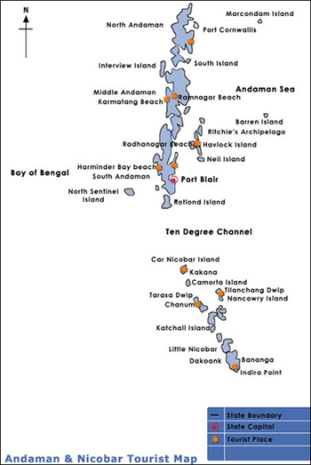
Andaman and Nicobar islands, Union Territory of India, is an archipelago of 572 islands in the Bay of Bengal stretching over 700 Kilo meters or 437.5 miles from North to South. Only 38 out of 572 islands are inhabited. The islands are spread between 92º to 94ºE longitude and 6º to 11ºN latitude, 1200 Kilo meters or 750 miles east of Chennai and 250 Kilo meters or 156.25 miles south of Kolkata and in close proximity to Burma and other South East Asian countries (especially Thailand, Indonesia, Malaysia etc).
Natural Landscape
The Andaman islands have a unique combination of white sand beaches, rising hills and dense equatorial forests. The heavy rainfall and location account for forest cover over 92% of the land. More than 50% of the forest area is Tribal Reserves, National Parks and Wild life sanctuaries.
A big percentage (nearly 11%) of the territory is occupied by mangroves makes Andaman as one of the dense mangroves in the world.
A big percentage (nearly 11%) of the territory is occupied by mangroves makes Andaman as one of the dense mangroves in the world.
Flora & Fauna :
The Andaman islands are very rich flora and fauna because of dense forest and vast seas. Andaman Islands is housing more than 150 endemic species of flora and fauna to the islands. There are over 1200 species of fishes, 246 varieties of birds (39 endemic) including the Megapod, Hornbill, Surfet and Nicobari Pigeon and 10% of the known varieties of Indian orchids present. Nesting of certain rare species of turtle is common to the islands. Coral life is found in abundance with 179 species belonging to 61 genera being reported.
The eco-diversity and its richness of Andaman Islands are its core strength.
Climate :
The tropical location of Andaman Islands provides uniform temperatures throughout the year with marginal monthly / seasonal variations. This suits the need of the European / US tourists seeking warmth and sunshine.
The Andaman and Nicobar islands are subject to both south-west and north-east that’s keeps the islands quite cool. With an average annual rainfall of over 3000 mm, the islands experience heavy rainfall especially between May – October.
Geographical & Demographic Profile
Area and Division
Andaman and Nicobar Islands are spread over a total area of 8249 square Kilo meters /5155.625 square miles, Andaman - 6408 square Kilo meters/4005 square miles and Nicobar - 1841 square Kilo meters/11051 square miles. The administrative units are provided below:
| Administrative Unit | Particulars |
|---|---|
| Districts | 2 |
| Sub divisions | 4 |
| Tahsil | 7 |
| Town | 1 |
| Lok Sabha seat | 1 |
| Inhabited Islands | 38 |
| Panchayats | 67 |
(* Source: Andaman Tourism plan 2003)
Population
Population is distributed across administrative units as follows:
| Administrative Unit | Population | % of population in ANI |
|---|---|---|
| Port Blair | 160022 | 45% |
| Ferragunj | 48618 | 14% |
| Diglipur | 42880 | 12% |
| Rangat | 38815 | 11% |
| Mayabunder | 23904 | 7% |
| Nancowry | 21753 | 6% |
| Car Nicobar | 20273 | 5% |
(*Source: Census 2001)
